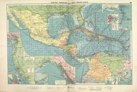
Central American and West Indian ports


 Maps, plans and nautical charts
Central American and West Indian ports (1922)
- Philip, George, 1870-1937
Maps, plans and nautical charts
Central American and West Indian ports (1922)
- Philip, George, 1870-1937
 Disponible Holdings
 Section: Maps, plans and nautical charts
Title: Central American and West Indian ports
Author: Philip, George, 1870-1937
Material or type of resouce Area: Escala 1:10.000.000
Publication: [London] ; [Liverpool] : George Philip & Son, Ltd : The London Geographical Institute : Philip, Son & Nephew, [1922]
Physical description: 1 mapa ; 49 x 72 cm
Content type: Imagen cartográfica
Media type: computadora
Carrier type: recurso en línea
Notes: Copia digital. Madrid : Ministerio de Cultura, 2010
Inserta mapas de: San Francisco ; Salina Cruz ; Puerto Mexico ; Mouths of the Mississippi ; Bermudas ; Kingston ; Havana ; Windward Islands ; The Pacific coast from San Diego to Vancouver ; The Pacific coast from Seattle to Dutch Harbor
Other titles: En: Philip's Mercantile Marine Atlas. - [London] : Edited by George Philip [et al.], 1922. - Mapa 24
Materia / lugar / evento: Rutas marítimas - Mapas
Puertos
América Central - Mapas
Genre / form: Cartas náuticas
Other authors: George Philip & Son
Merchant, Shippers, Exported and Ocean Travelles
London Geographical Institute
Related titles: América Central. Mapas generales. 1922
UDC: (728)
(729)
Type of publication:
Maps
Préstamo:
 Disponible sólo para consulta en sala
