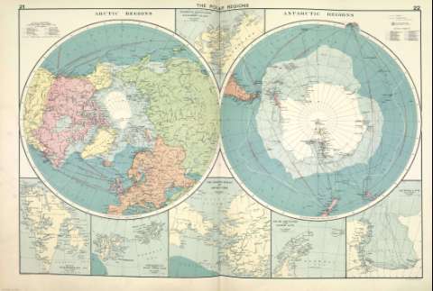
The Polar Regions


 Disponible Holdings
 Section: Maps, plans and nautical charts
Title: The Polar Regions
Author: Philip, George, 1870-1937
Material or type of resouce Area: 1:35.000.000
Publication: [London] ; [Liverpool] : George Philip & Son, Ltd : The London Geographical Institute : Philip, Son & Nephew, [1922]
Physical description: 1 mapa ; 49 x 72 cm
Content type: Imagen cartográfica
Media type: computadora
Carrier type: recurso en línea
Notes: Copia digital. Madrid : Ministerio de Cultura. Dirección General del Libro, Archivos y Bibliotecas, 2010
Incluye: Northern Greenland and Ellesmere Island ; West Spitsbergen ; Spitsbergen and Franz Josef Land ; The Bering Strait and Lower Yukon ; South Shetlands and Graham Land ; Victoria Land
Other titles: En: Philip's Mercantile Marine Atlas. - [London] : Edited by George Philip [et al.], 1922. - Mapa 28
Materia / lugar / evento: Rutas marítimas - Mapas
Regiones polares - Mapas
Genre / form: Atlas mundiales
Other authors: George Philip & Son
Merchant, Shippers, Exported and Ocean Travelles
London Geographical Institute
Related titles: Regiones polares. Mapas generales. ca. 1922
UDC: (98/99)
Type of publication:
 Maps
Maps
Préstamo:
 Disponible sólo para consulta en sala
