Palästina im maassstabe von 1:1.200.000 : [generalkarte]


 Maps, plans and nautical charts
Palästina im maassstabe von 1:1.200.000 : [generalkarte] (1879)
- Petermann, Augustus, 1822-1878
Maps, plans and nautical charts
Palästina im maassstabe von 1:1.200.000 : [generalkarte] (1879)
- Petermann, Augustus, 1822-1878
 Disponible Holdings
 Section: Maps, plans and nautical charts
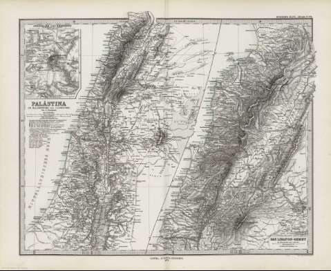
Title: Palästina im maassstabe von 1:1.200.000 : [generalkarte] / von A. Petermann ; gest. v. Eberhardt & Grunert
Author: Petermann, Augustus, 1822-1878
Material or type of resouce Area: Escala 1:1.200.000 (E34 00'-E38 00'/N34 30'-N31 00')
Publication: Gotha [Alemania] : Justus Perthes, 1879
Physical description: 1 mapa : col. ; 34x28 cm, en h. de 39x48 cm, pleg. en 39x24 cm
Content type: Imagen cartográfica
Media type: computadora
Carrier type: recurso en línea
Notes: Constan además coordenadas según el meridiano de París y Ferro
Relieve : líneas perpendiculares normales
Leyenda de signos utilizados
Inserta : Jerusalem und Umgegend. - Escala 1:150000 -- Das Libanon - Gebiet.- Escala 1:500.000
En el margen superior derecho : "Stieler's Hand-Atlas Nº 61"
Copia digital . España : Ministerio de Cultura y Deporte. Subdirección General de Coordinación Bibliotecaria, 2010
Other titles: En: Hand atlas : über alle Theile der Erde und über das Weltgebäude. - Gotha [Alemania R.D.] : Justus Perthes, [1879]. - N 61
Other authors: Eberhardt, Hermann, 1811-1885
Stieler, Adolf, 1775-1836
Grunert
Justus Perthes (Firma)
Related titles: Oriente Medio. Mapas generales (1879). 1:1200000
UDC: 912:341.222(569.4+569.3)'1879'
569.4
569.3
Type of publication:
Maps
Rights:
