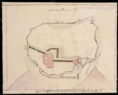
Alcalá la Real (Castillo, Fuerte)


 Maps, plans and nautical charts
Alcalá la Real (Castillo, Fuerte) (Cádiz en 20 del mes de Mayo de 1811)
Maps, plans and nautical charts
Alcalá la Real (Castillo, Fuerte) (Cádiz en 20 del mes de Mayo de 1811)
 Disponible Holdings
 Section: Maps, plans and nautical charts
Uniform title: ALCALÁ LA REAL (Jaén). Fuertes (1811?). 1:800
Title: Alcalá la Real (Castillo, Fuerte) / copiado por José Pil
Material or type of resouce Area: Escala [ca. 1:800]. 20 toesas [= 4,9 cm]
Publication: Cádiz en 20 del mes de Mayo de 1811
Physical description: 1 plano : ms., col., montado sobre tela ; 18,1 x 22,3 cm
Content type: Imagen cartográfica
Media type: computadora
Carrier type: recurso en línea
Notes: Título propio, manuscrito con posterioridad, en el ángulo superior derecho
Manuscrito firmado por el autor. A plumilla en tinta negra y coloreado a la acuarela en carmín
Relieve representado por sombreado
Materia / lugar / evento: Fuertes
Guerras de independencia
1811
Alcalá la Real
Jaén (Provincia)
Andalucía
España
España - Historia - 1808-1814 (Guerra de la Independencia)
Genre / form: Manuscritos
UDC: (460.352 Alcalá la Real)
Type of publication:
Maps
Rights:
Préstamo:
Disponible
