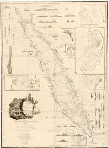
A Chart of the Arabian Gulf or Red Sea


 Disponible Holdings
 Section: Maps, plans and nautical charts
Uniform title: MAR ROJO. Cartas náuticas (1781). 1:2000000
Title: A Chart of the Arabian Gulf or Red Sea / By L.S. de la Rochette
Material or type of resouce Area: Escala [ca. 1:2000000]
Publication: London : Published by William Faden (Successor to the late T. Jefferys, Geographer to the King Charing Cross, August, 14th, 1781
Physical description: 1 carta nautica : montado sobre tela ; 115,5x8 cm en h. de 119x88 cm, pleg. en 30x66 cm
Content type: Imagen cartográfica
Media type: computadora
Carrier type: recurso en línea
Notes: Presenta además diez perfiles y seis mapas de detalle de Suaken Harbour and Island, The Road of Mocha, The Road of Gedan
Coordenadas referidas al meridiano de Londres (E31°15'-E45°11'/N30°30'-11°11'). Orientado con lis en o en nudo de 8 rumbos prolongados
Relieve representado por sondas batimetricas
Indica veriles, bajos y fondeaderos
Titulo enmarcado en cartela barroco con motivos manus
Procede de la Colección Rico y Sonolas
Entelado en 26 cuarterones
Other authors: Faden, William, 1749-1836
UDC: 912:[551.46:528.9](267.33)'1781'
267.33
Type of publication:
 Maps
Maps
Rights:
Préstamo:
Disponible
