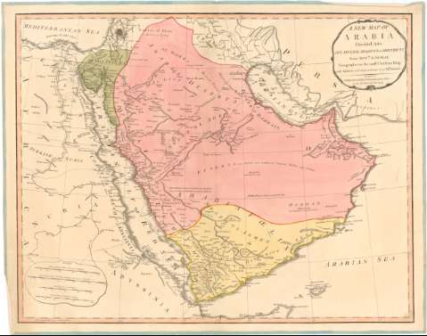
A new map of Arabia : divided into its several regions...


 Maps, plans and nautical charts
A new map of Arabia : divided into its several regions and districts (May 12th 1794)
Maps, plans and nautical charts
A new map of Arabia : divided into its several regions and districts (May 12th 1794)
 Disponible Holdings
 Section: Maps, plans and nautical charts
Uniform title: Arabia (Península). Mapas generales (1794). 1:5000000
Title: A new map of Arabia : divided into its several regions and districts / from Monse. D'Anville Geographer to the most Christian King, with additions and improvements from Mr. Niebuhr
Material or type of resouce Area: [Ca. 1:5000000], 250 great arabian miles about 50 to degrée [= 9,7 cm]
Publication: London : published by Laurie and Whittle 53 Fleet Street, May 12th 1794
Physical description: 1 mapa : col., montado sobre tela ; 50,3 x 63,7 cm
Content type: Imagen cartográfica
Media type: computadora
Carrier type: recurso en línea
Notes: Escalas gráficas de 100 leguas persas cerca de 15 al grado [= 11,7 cm], 80 leguas de 20 al grado [= 7,9 cm] y 300 millas inglesas de 69 1/2 al grado [= 8,6 cm]. Coordenadas referidas al meridiano de Hierro (E 45°30'-E 80°30'/N 33°00'-N11°00'). Red geográfica de 5° en 5°
Relieve de perfil
Título en cartela orlada
Materia / lugar / evento: Mapas generales
Divisiones administrativas
Penínsulas
1794
Jordania
Arabia Saudí
Yemen
Omán
Arabia
Asia
UDC: 912(53-2/-5)'1794'
(532)
(533)
(534)
(535)
Type of publication:
Maps
Rights:
Préstamo:
Disponible
