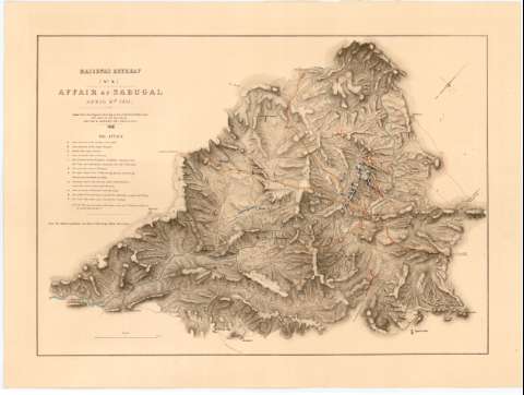
Affair of Sabugal, April 3rd. 1811


Section: Maps, plans and nautical charts
Title: Affair of Sabugal, April 3rd. 1811 / Coll. Sir H. James... Director
Material or type of resouce Area: Escala [ca. 1:500000], 2 miles [= 6,4 cm]
Publication: London : Lithod. from the Original Drawing in the Qr. Mr. Genls. Office, at the Topl. Dept. of the Water Office, 1868
Physical description: 1 mapa : col. ; 39,2x55,2 cm en h. de 47,5x63,5 cm
Content type: Imagen cartográfica
Media type: computadora
Carrier type: recurso en línea
Notes: Pertenece al 'Massena's Retreat' ; N 10
Orientado con flecha en cuadrante
Relieve representado por normales
Relación de las principales lineas de ataque de los ejércitos, indicadas por clave alfabética
Nota relativa a las posiciones de las tropas antes del ataque
Indica vegetación y las posiciones de los ejércitos por clave cromática
Materia / lugar / evento: Guerras de independencia
Operaciones bélicas
Estrategia militar
1811
Sabugal
Other authors: James, H Sir
Gran Bretaña. War Office
UDC: 912:[355.4:355.46](469-328 Beira Alta)'1811'
(469 Sabugal)
Type of publication:
 Maps
Maps
Rights:
Préstamo:
 Disponible
