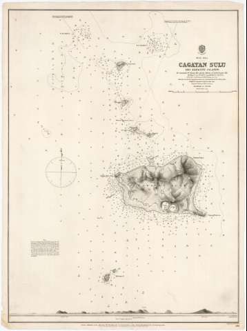
Cagayan Sulu and adjacent islands


 Disponible Holdings
 Section: Maps, plans and nautical charts
Uniform title: Cagayan (Filipinas) (Isla). Cartas náuticas (1873). 1:70000
Title: Cagayan Sulu and adjacent islands / by Commander W. Chimmo R.N. and the Officiers of H.M.S. "Nassau" 1871; engraved by Edwa. Weller
Material or type of resouce Area: Escala 1:70000
Publication: London : Published at the Admiralty... under the Superintendence of Rear Admiral G.M. Richards, C.B.F.R.S. Hydrographer, 24 th. Mar. 1873
Physical description: 1 carta náutica ; 66 x 49 cm
Content type: Imagen cartográfica
Media type: computadora
Carrier type: recurso en línea
Series: (Sulu Sea)
Notes: Escala en fracción representativa y gráfica de 4 millas marinas [= 9'9 cm]. Indica gráfico de declinación magnética
Relieve representado por normales y puntos acotados
Indica sondas batimétricas, bajos, veriles y calidad del fondo
Notas explicativas sobre las sondas, las altitudes señaladas y la variación magnética (de 1873), así como explicación de las características del mejor fondeadero de la isla
Sello impreso del "Hydrographic Office G.H.R."
En margen inferior : "View of Cagayan Sulu from A"
Procede de la "Colección Coello"
Materia / lugar / evento: Cartas náuticas
Islas
Perspectivas de costas
1873
Mar de Sulu
Other authors: Chimmo, William
Weller, Edward
Gran Bretaña. Hydrographic Department
UDC: 599
Type of publication:
 Maps
Maps
Rights:
Préstamo:
Disponible
