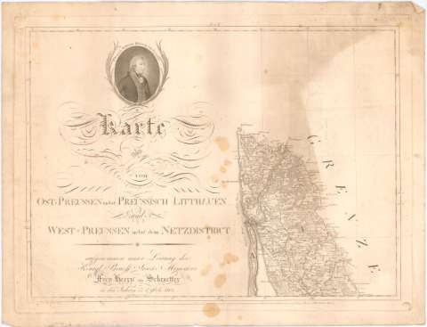
Karte von Ost - Preussen nebst Preussisch Litthauen und...


 Maps, plans and nautical charts
Karte von Ost - Preussen nebst Preussisch Litthauen und West - Preussen nebst dem Netzdistrict (1796-1809)
Maps, plans and nautical charts
Karte von Ost - Preussen nebst Preussisch Litthauen und West - Preussen nebst dem Netzdistrict (1796-1809)
 Disponible Holdings
 Section: Maps, plans and nautical charts
Uniform title: Polonia. Mapas generales (1796-1809). 1:150000
Title: Karte von Ost - Preussen nebst Preussisch Litthauen und West - Preussen nebst dem Netzdistrict / aufgenommen unter Leitung des Konigl Preusfl Staats Ministers Frey [...] von Schrocetter ; gestochen von Carl Jack ; vollendet von Carl Mare
Material or type of resouce Area: Escala [ca. 1:150000], 4 Preufs. Meilen á 2000 Ruthen Rheinl [= 24,6 cm] ; [proyec. cónica]
Publication: Berlin : Carl Jack, 1796-1809
Physical description: 1 mapa en 25 h. ; 336x378 cm en h. de 48x63 cm
Content type: Imagen cartográfica
Media type: computadora
Carrier type: recurso en línea
Notes: Presenta además 2 planos de población de las ciudades de Gdarisk y Kaliningrad grabados por Paulus Schmidt
Escalas gráficas de 3 Meilen, 6 Lieues, 17 Yards y 25 Werste
Coordenadas referidas, al parecer, al meridiano de Hierro (E33°03'-E40°35'/N56°06'-N52°16'). Red geográfica de 10' en 10'
Relieve representado por normales y sombreado
Relación de las principales divisiones administrativas indicadas por clave alfabética
Tabla de signos convencionales para indicar núcleos de población de diferente categoria, fortificaciones, campos de batalla, límites administrativos, molinos, oficinas postales, ríos, praderas y pantanos
Tabla de datos topográficos de las principales poblaciones según zonas, en la h. XIX
Nota relativa a datos históricos, en la h. XXV
Sello en seco del Depósito General de la Guerra
En el ángulo superior izquierdo de la hoja I aparece retrato de Friedrich Willhelm III, rey de Prusia
Inserta : General Tableau Zur Karte von Alt - Ost und Westpreussen nebst dem aufgenommen Trigonometrischen Netz / gestochen von Heinrich Kliewer. - Escala [ca. 1:11000000], 15 Meilen a 2000 brand Ruthen [= 11 cm]
Materia / lugar / evento: Mapas generales
Fortificaciones
Topónimos antiguos
S.XIX
Kaliningrado
Gdansk
Other authors: Jaeck, Carl
Maré, M. C
Schmidt, Paulus
Kliewer, d'A. Heinrich
UDC: 912:623.2](438-17)'1796/1809'
(474.5 Kaliningrad)
(438 Gdansk)
Type of publication:
Maps
Rights:
Préstamo:
Disponible
