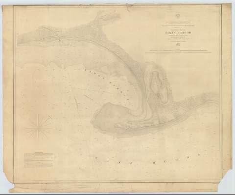
Preliminary Chart of Tawas Harbor [sic] (Harbor [sic] of...


 Mapas, planos y cartas náuticas
Preliminary Chart of Tawas Harbor [sic] (Harbor [sic] of Rejuge Lake Huron) (1857?)
Mapas, planos y cartas náuticas
Preliminary Chart of Tawas Harbor [sic] (Harbor [sic] of Rejuge Lake Huron) (1857?)
 Disponible Ejemplares
 Sección: Mapas, planos y cartas náuticas
Título uniforme: TAWAS (Estados Unidos) (Bahía). Cartas náuticas. 1857 (1856). 1:16000
Título: Preliminary Chart of Tawas Harbor [sic] (Harbor [sic] of Rejuge Lake Huron) / Surveyed under the direction of Captain J.N. Macomb Topl. Engs. G.W. Lawson, H. Graham, A.C. Lamson 1856 ; made in obedience to acts of congress and under the direction of The Bureau of Topographical Engineers of the War Department
Área de datos: Escala 1:16000
Publicación: [Washington] : Bureau of Topographical Engineers of the War Department, [1857?]
Descripción física: 1 carta náutica ; 61 x 73 cm
Tipo de contenido: Imagen cartográfica
Tipo de medio: computadora
Tipo de soporte: recurso en línea
Serie: (Survey of the Northern and North Western Lakes)
Notas: Escala también dada en formas gráficas de 1 milla legal y 1 milla náutica. Orientado con nudo de treintaidos rumbos, en la que señala además la variación magnética observada
Fecha tomada del sello que figura en el documento
Relieve por normales
Indica sondas batimétricas y veriles, así como las distintas líneas de derrota a seguir para arribar a la bahía
En nota se explican las derrotas consejables para navegar por la bahía
Materia / lugar / evento: Cartas náuticas
Batimetría
Bahías
1856
1857
Otros autores: Macomb, J. N
Lawson, George William
Graham, H
Lawson, A.G
Estados Unidos. War Department. Engineer Bureau
CDU: 774-11
Tipo de publicación:
Mapas
Derechos:
Préstamo:
Disponible
