Territory of the United States from the Mississippi River...


 Mapas, planos y cartas náuticas
Territory of the United States from the Mississippi River to the Pacific Ocean : originally prepared to accompany... (1873)
Mapas, planos y cartas náuticas
Territory of the United States from the Mississippi River to the Pacific Ocean : originally prepared to accompany... (1873)
 Disponible Ejemplares
 Sección: Mapas, planos y cartas náuticas
Título uniforme: TEXAS (Estados Unidos). Mapas generales. 1873 (1873). 1:3000000
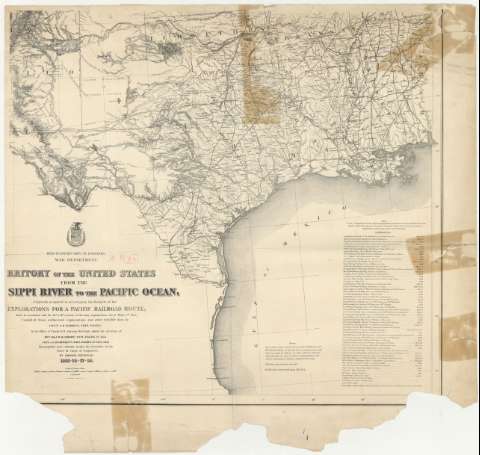
Título: Territory of the United States from the Mississippi River to the Pacific Ocean : originally prepared to accompany the Reports of the explorations for a Pacific Railroad route / made in accordance with the 10th & 11th sections of the Army Appropriaton,Act of March 3rd. 1853 ; compiled from authorized explorations and other reliable data by lieut. G.K. Warren, Topl. engrs. in the office of Pacific R.R. Surveys, War Dept., under the directión of B.V.T. Maj. W.H. Emory, Topl. engrs. in 1854-1858 ; Recopiled and redrawn under the direction of the chief of Corps of engineers by Edward Freyhold 1865-66-67.
Área de datos: Escala 1:3000000 (O 105° -- O 90°/N 35° -- N 31°)
Publicación: [Washington] : Headquarters Corps of Engineers. War Department, 1873
Descripción física: 1 mapa ; 54 x 60 cm
Tipo de contenido: Imagen cartográfica
Tipo de medio: computadora
Tipo de soporte: recurso en línea
Notas: Comprende los estados de Texas, Luisiana, las partes meridionales de los de Oklahoma y Arkansas, la suroriental del de Nuevo México y la occidental del de Mississippi, en los Estados Unidos
Escala también dada en forma gráfica de 200 millas estatutarias
Relieve por normales
En el margen inferior: "Rail Roads corrected June 5th. 1873"
Documento incompleto pués falta un número indeterminado de hojas
Materia / lugar / evento: Mapas generales
Divisiones administrativas
Líneas ferroviarias
Proyectos
1873
Oklahoma
Mississippi
Arkansas
Luisiana (Estados Unidos, Estado)
Otros autores: Warren, Gouverneur Kemble, 1830-1882
Emory, William Hemsley
Freyhold, Edward
Estados Unidos. Army. Corps of Engineers
CDU: (763)
Tipo de publicación:
Mapas
Derechos:
Préstamo:
Disponible
