Plan of the Island of Dominica : laid down by Actual...


 Mapas, planos y cartas náuticas
Plan of the Island of Dominica : laid down by Actual Survey under the Direction of the Honorable The Commissioners... (Novr. 1st. 1776)
Mapas, planos y cartas náuticas
Plan of the Island of Dominica : laid down by Actual Survey under the Direction of the Honorable The Commissioners... (Novr. 1st. 1776)
 Disponible Ejemplares
 Sección: Mapas, planos y cartas náuticas
Título uniforme: Dominica. Mapas generales. 1776. 1:32.000
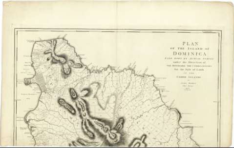
Título: Plan of the Island of Dominica : laid down by Actual Survey under the Direction of the Honorable The Commissioners for the Sale of Lands in the Ceded Islands / by John Byres Chief Surveyer ; J. Bayly Sculp. London
Área de datos: Escala [ca. 1:32000]
Publicación: London : Published by S. Hooper N 25 Ludgate Hill, Novr. 1st. 1776
Descripción física: 1 mapa en 3 h. ; 156 x 91 cm., en h. de 65 x 101 cm o menos
Tipo de contenido: Imagen cartográfica
Tipo de medio: computadora
Tipo de soporte: recurso en línea
Notas: Dedicatoria: "To His Excellency Thoman Shirley Esqr. Captain General & Governor in Chief of His Majesty's Island of Dominica, the Hororable William Stuart Esqr. lieutenant Governor the Gentlennen of the Council and Assembly, and to the Propietors in General of Lands in the Said Island this plan is most respectully Ynscribed By Their most Obedient and most Humble servant John Byres"
Escala gráfica de 4 millas estatuarias [= 20 cm]. Coordenadas referidas al meridiano de Hierro (O 43°44'30''-O 43°29'00''/N 15°45'00''-N 15°19'00'') y Londres (O 61°19'30''-O 61°04'00''/N 15°45'00''-N 15°19'00''). Orientado con lis en rosa de 8 vientos
Relieve representado por normales
Indica bajos, fondeaderos y sondas batimétricas
Señala las divisiones parcelarias
Notas explicativas del mapa
Materia / lugar / evento: Mapas generales
Islas
Parcelación
1776
Otros autores: Byres, John
Bayly, John, fl. 1755-1794
Hooper, Samuel
CDU: 729.821
Tipo de publicación:
Mapas
Derechos:
Préstamo:
Disponible
