A Map of the Inhabited part of Canada from the French...


 Mapas, planos y cartas náuticas
A Map of the Inhabited part of Canada from the French Surveys : with the Frontiers of New York and New England from... (1777)
Mapas, planos y cartas náuticas
A Map of the Inhabited part of Canada from the French Surveys : with the Frontiers of New York and New England from... (1777)
 Disponible Ejemplares
 Sección: Mapas, planos y cartas náuticas
Título uniforme: América del Norte. Mapas topográficos (1777). 1:804675
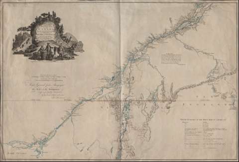
Título: A Map of the Inhabited part of Canada from the French Surveys : with the Frontiers of New York and New England from the Large Survey / By Claude Joseph Sauthier ; Engraved by Wm. Faden, 1777
Área de datos: [Ca. 1:804.675]
Publicación: London, Corner of St. Martin's Lane, Charing Cross : Published ... by Wm. Faden, 1777
Descripción física: 1 mapa : col. ; 57 x 84 cm
Tipo de contenido: Imagen cartográfica
Tipo de medio: computadora
Tipo de soporte: recurso en línea
Notas: Dedicatoria: "To Major General John Burgoyne This Map,is, by His Permission, most respectfully Inscrib'd... Wm. Faden"
Escalas gráficas expresadas en millas estatutarias de 69 1/2 al grado y leguas canadienses de 2 1/2 al grado
Indicación de la latitud: paralelo 45
En tinta azul los ríos, roja las divisiones administrativas y amarillo el paralelo
Explicación sobre la representación cartográfica de los territorios adyacentes al del mapa
Indice de los cuarteles de invierno del ejército canadiense en 1776 y su localización geográfica
Titulo comprendido en un grabado decorativo en el ángulo superior izquierdo
Materia / lugar / evento: Mapas topográficos
América del Norte
Otros autores: Faden, William, 1749-1836
CDU: 912:355.31(7-927.5)"1777"
7-927.5
Tipo de publicación:
Mapas
Derechos:
Préstamo:
Disponible
