The Coast of Nova Scotia, New England, New York, New...


 Mapas, planos y cartas náuticas
The Coast of Nova Scotia, New England, New York, New Jersey, the Gulph and River of St. Lawrence, the Islande of New... (1780)
- Des Barres, Joseph F. W (Joseph Frederick Wallet), 1722-1824
Mapas, planos y cartas náuticas
The Coast of Nova Scotia, New England, New York, New Jersey, the Gulph and River of St. Lawrence, the Islande of New... (1780)
- Des Barres, Joseph F. W (Joseph Frederick Wallet), 1722-1824
 Disponible Ejemplares
 Sección: Mapas, planos y cartas náuticas
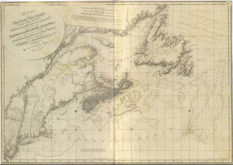
Título: The Coast of Nova Scotia, New England, New York, New Jersey, the Gulph and River of St. Lawrence, the Islande of New foundland, Cape Breton, St. John, Antecast, Sable : and soundings thereot / Published for the use of the Royal Navy of Great Batain, under the Authority of the Right. Honble. the Lord's Commissioners of the Admiraty, by Jor... Des Barres Esgr. 1780 ; [H. Tomkins Script, H. Ashby Sculptit]
Área de datos: Escala [ca. 1:1890000] ; [proy. Mercator] (O 75°40'-O 48°10'/N 52°30-N 39°10)
Publicación: [London?] : J. F. W. Des barres, 1780
Descripción física: 1 mapa ; 84 x 117 cm, pleg. en 70 x 62 cm
Tipo de contenido: Imagen cartográfica
Tipo de medio: computadora
Tipo de soporte: recurso en línea
Notas: The Sea Coast of Nova Scotia, Nº 1
Carta náutica de parte de la fachada atlántica de Norteámerica, que comprende Nueva Inglaterra, Nueva Escocia, e islas adyancentes ; y en la que se determina batimetría en sondas, y veriles, y calidad del fondo
Orientado con tres nudos de 32 rumbos ; dos de ellos con lis
Escalas gráficas en millas náuticas, leguas de 20 al grado y millas legales
Coordenadas referidas al meridiano de Greenwich
Toponímia costera
Título enmarcado en cartela circular, que ocupa el ángula superior izquierdo
Presenta relación y notas explicativas sobre las mareas, sondas, tipos de fondo, corrientes y grado de declinación magnética
Registros relacionados: En: The Atlantic Neptune. - [London?] : J. F. W. Des Barres, 1774- 1780. - 1
Otros autores: Ashby, Harry, 1744-1818
Tomkins, Thomas, 1743-1816
Títulos secundarios: Estados Unidos. Cartas náuticas. 1780. 1:1890000
CDU: 912:551.46]:551.468:551.42(73)"1780"
73
Tipo de publicación:
Mapas
Préstamo:
 Disponible sólo para consulta en sala
