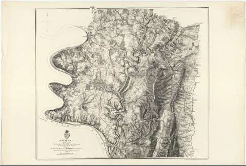
Antietam


 Disponible Ejemplares
 Sección: Mapas, planos y cartas náuticas
Título: Antietam / prepared by But. Genl. N. Michler, Major of Engineers from Surveys under his direction by Order of Brig. Genl. & But. Maj. Genl. A.A. Humphreys, Chief of Engineers and under the Authority of the Hon. Secretary of War. 1867 ; Surveyed & drawn by Maj. J.E. Weyss, assisted by F. Theilkuhl, J. Strasser & G. Thompson
Área de datos: Escala [ca. 1:21120]
Publicación: N.Y. : Photolith. by the N.Y. Lithographing, engraving & Printing Co. Julius Bien, Supt., 1869
Descripción física: 1 mapa ; 57 x 65 cm
Tipo de contenido: Imagen cartográfica
Tipo de medio: computadora
Tipo de soporte: recurso en línea
Notas: Presenta la ciudad de Sharpsburg y parte de los alrededores, destacando en rojo la línea del frente ocupado por las tropas confederadas durante la batalla de Antietan (16 y 17 de Septiembre de 1862)
Escala nominal de 3 pulgadas por milla. Orientado con flecha, con las iniciales de los puntos cardinales
Orografía por normales
Sobre el título figura impreso un escudo, posiblemente de la Secretaría de Guerra, con la fecha de publición
Relacionado con los mapas SG-J-2-3--151 a 166
Materia / lugar / evento: Operaciones bélicas
Mapas topográficos
Batalla de Antietam
1862
Maryland
Estados Unidos
Otros autores: Michler, N
Bien, Julius, 1826-1909
Weyss, J. E
Theilkuhl, F
Strasser, J
Thompson, G
CDU: 912:355.4:355.43(752)"1862"
752 Sharpsburg
Tipo de publicación:
 Mapas
Mapas
Derechos:
Préstamo:
Disponible
