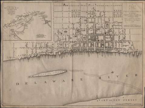
A Plan of the City of Philadelphia, the Capital of...


 Maps, plans and nautical charts
A Plan of the City of Philadelphia, the Capital of Pennsylvania (1776)
Maps, plans and nautical charts
A Plan of the City of Philadelphia, the Capital of Pennsylvania (1776)
 Disponible Holdings
 Section: Maps, plans and nautical charts
Uniform title: Filadelfia. Planos de población. 1776. 1:5.000
Title: A Plan of the City of Philadelphia, the Capital of Pennsylvania / from an Actual Survey by Benjamín Easburn ; P. André sculp
Material or type of resouce Area: Escala [ca. 1:5.000]. 2000 feet [= 12,1 cm]
Publication: London : Published, as the Act directs... by Andrew Dury, Duke's Court, St. Martin's Lane, 1776
Physical description: 1 plano : grab. ; 50 x 67 cm
Content type: Imagen cartográfica
Media type: computadora
Carrier type: recurso en línea
Notes: Escala también expresada en 15 Miles 60 to a Degree [= 4 cm]
Orientado con lis
Inserta: A chart of Delaware Bay and River from the Original / by Mr. Fisher of Philadelphia 1776. - Escala [ca. 1:700.000]. 20 English Miles 69 1/2 to a Degrée [= 4,5 cm]
Materia / lugar / evento: Planos de población
Filadelfia
Pensilvania
Estados Unidos
Other authors: Easburn, Benjamín
André, Peter
Dury, Andrew
UDC: (748 Filadelfia)
Type of publication:
Maps
Rights:
Préstamo:
Disponible
